Blog
Charyn Canyon from Almaty: Complete Travel Guide — 2026 Prices, Routes, Seasons and Life Hacks
Charyn Canyon is one of the main natural attractions of Kazakhstan, located 200 km from Almaty. The drive takes 3–3.5 hours along the A-3 highway. Key points: the Valley of Castles, the observation deck, and the Charyn River. The best season is April–October. Entry fee is 500 tenge. A tour from Almaty with toor starts from 12,000 tenge per person, including transfer, guide, and lunch.
What is Charyn Canyon and what makes it unique
Charyn Canyon is a natural monument 200 km east of Almaty, which in scale and geological age is second only to the Grand Canyon, and in accessibility for tourists surpasses any gorge in the Tien Shan. Let's explore what makes it interesting and why you should visit.
Where is Charyn Canyon located and what is its geography
This natural site is located 200 km east of Almaty, within the Charyn National Park. Its length is 154 km, the depth of the gorge ranges from 150 to 300 m, and the width at its narrowest point, where the tourist trail "Valley of Castles" is laid, reaches only 80 m. The canyon is carved by the Charyn River, which originates in the Ketmen Ridge and flows along the bottom of the gorge year-round — even during the driest summer months, the water level does not drop critically, and riffles up to half a meter deep remain in the riverbed. Due to the elevation difference and the shape of the gorge, the temperature at the bottom of the canyon in summer is 5–7°C lower than above, which provides relief in the heat, but intensifies the cold in winter, so in January it can be as low as –25°C at the bottom compared to –15°C on the plateau.
How Charyn Canyon differs from other canyons in Kazakhstan
Unlike the gorges in the Zailiysky Alatau mountains, this canyon is composed of red and orange sedimentary rocks about 12 million years old, creating the unique landscape of the "Valley of Castles" — whimsical rock towers resembling the ruins of a medieval fortress. For comparison: the cliffs of the Turgen or Aksai gorges are gray-green granites and schists, while the rocks of the Kolsai Lakes are dark tuffs and basalts. The red sandstones and clays of Charyn are the former bottom of the ancient Tethys Ocean, so fossils of marine organisms can be found in the rocks: ammonites, belemnites, and even imprints of bivalve shells, which are clearly visible in the outcrops along the trail.
When to go: seasons and weather by month
Let's break down the weather by season so you know when to plan your trip and what to bring. We'll account for the microclimate of the gorge — it differs from Almaty's by 5–10°C in either direction.
Summer (June–August): heat above and coolness in the gorge
In summer, on the canyon plateau, daytime temperatures are +30…+35°C, while in the gorge it is 5–7°C cooler, making the walk comfortable even at the peak of the heat. The best time to visit is before 11:00 AM or after 4:00 PM, when the sun does not beat directly on the sheer walls of the Valley of Castles. At noon, the shade almost disappears, and the rocks heat up to +45°C to the touch — without a hat and 1.5 liters of water per person, you should not enter the route. In July and August, the dirt road leading to the canyon dries out and becomes hard — you can even drive a sedan, unlike during the spring thaw.
Spring and autumn (April–May, September–October): the ideal season
The best season for a trip is April–October, with the peak in May–September. In April and October, daytime temperatures are +15…+20°C, in May and September — +20…+25°C, which is ideal for hiking: you won't be drenched in sweat climbing to the observation deck, nor will you freeze in the shade of the gorge. In May, wild tulips and irises bloom on the plateau, and in September, the air is clearer — the panorama of the Valley of Castles is visible for 15–20 km. In March–April, rains are possible, which wash out the 10-km stretch of dirt road — during this period, it is better to go in an SUV or with a tour where the transport is adapted to the road.
Winter (November–March): for whom and how to prepare
In winter, daytime temperatures in the canyon are -5…-10°C, and at night the temperature drops to -20°C. Due to the wind blowing into the gorge from the east, the cold feels 5–8°C stronger than the thermometer shows — without a windproof jacket and thermal underwear, the walk will become a trial. Snow here is rare and lasts no more than a week, so the trail to the Valley of Castles remains passable. In winter, the canyon is almost deserted, and the walls covered with frost look completely different than in summer — this is an option for those seeking solitude and not afraid of the cold.
Season comparison: temperature, precipitation, road
| Season | Months | Daytime temperature | Road (A-3 highway + dirt road) | What to bring |
|---|---|---|---|---|
| Spring | March–April | +10…+20°C | Dirt road may be washed out after rains | Windbreaker, waterproof shoes |
| Summer | May–August | +30…+35°C (above), +25…+28°C (in gorge) | Dry, passable in any car | Water 1.5 L, hat, sunscreen |
| Autumn | September–October | +15…+25°C | Dry, passable in any car | Windbreaker, comfortable shoes |
| Winter | November–February | -5…-10°C | Dirt road may be slippery | Warm clothing, thermal underwear, wind protection |
Even in peak season (July–August), bring a windbreaker — the wind in the gorge can be cool, especially towards evening.
How to get there from Almaty: car, taxi, tour
Let's break down three ways to get to Charyn Canyon from Almaty: by your own car, by taxi, and with a tour. Each has its own pros, cons, and cost.
By car: route, road, nuances
The drive from the city to the canyon takes 3–3.5 hours: 190 km along the A-3 highway (Kegen direction) and 10 km of dirt road to the entrance. Entrance ticket is 500 KZT per person, parking is 200 KZT, payment on site by cash or Kaspi QR. Fuel for the round trip takes about 40 liters — at a price of 210 KZT for AI-95, that's approximately 8,400 KZT. The navigator guides confidently, but there is no signal at the bottom of the canyon — download the map in advance on 2GIS or Maps.me. The nearest gas station is in the village of Shelek, 45 km before the canyon; check the spare tire and coolant level before departure. The dirt road becomes difficult for a sedan after rains — if you're going in spring, take an SUV or crossover; in summer the ground is hard, any car will pass.
By taxi: cost and features
A taxi to Charyn Canyon one way — from 25,000 KZT for a sedan, round trip with waiting (5–6 hours) — 60,000–65,000 KZT per day. The driver may request a prepayment for downtime if you are delayed longer than the agreed time — clarify this when ordering. The trip provides only transfer: without a guide and route preparation, it's easy to waste time finding the entrance to the Valley of Castles, and you'll have to bring lunch in a thermos or buy it at the only cafe near the entrance for 1,500–2,000 KZT.
With a toor tour: what's included and how much it costs
A tour to Charyn Canyon from toor costs from 12,000 KZT per person and includes transfer by minibus, services of a local guide, lunch, and insurance — no extra charges. The guide knows the key points: the Valley of Castles, a viewpoint with a 180-degree panorama, the descent to the Charyn River, and will also tell you about the canyon's geology and the history of the Saka burial mounds along the way. Departure at 8:00 from Republic Square, return by 19:00 — you get to see the main sights without worrying about the road, food, or navigation. In a group of up to 12 people, the guide adjusts the walking pace to the participants and helps with photos on the route from 1 to 7 km.
Comparison of methods: cost, time, convenience
| Parameter | Independently (car) | Taxi | toor tour |
|---|---|---|---|
| Cost per person | ~5,000 KZT (fuel + entrance + parking) | from 25,000 KZT one way | from 12,000 KZT (all inclusive) |
| Travel time | 3–3.5 hours | 3–3.5 hours | 3–3.5 hours |
| Guide | No | No | Local guide |
| Lunch | Need to bring your own | Need to bring your own | Included |
| Transfer | Own car | Taxi | Minibus |
| Route organization | Self-organized | Self-organized | Guide leads the group |
| Insurance | No | No | Included |
With a group of 3 or more people, a toor tour is cheaper than a taxi and includes a guide and lunch — saving not only money but also time on organization.
What to see: routes and key points
In Charyn Canyon, there are several routes — from a short walk to a full trek. Let's break down each: distance, difficulty, what you'll see.
Valley of Castles — viewpoint (1 km, easy route)
The most popular route — from the entrance to the viewpoint of the Valley of Castles: 1 km one way with minimal elevation change, suitable for children and the elderly, walking time — 20–30 minutes. The trail is dirt, flat, without steep climbs — along the way there are rock outcrops of red sandstone with bizarre shapes resembling towers and fortress walls. From the platform itself, a panorama opens up of 200-meter sheer walls, which glow orange-pink at sunset — this is the best shot for a photo. If you came for 2–3 hours, stick to this route: it gives the main impression without the risk of getting tired.
Descent to the Charyn River (7 km, moderate difficulty)
The route to the Charyn River and back — 7 km with an elevation change of about 100 m, the trail goes along the canyon floor and takes 2–3 hours depending on pace. Sections with scree and large rocks require sturdy shoes with tread — sneakers with smooth soles slip on sandstone. At the bottom, the riverbed opens up, 10–15 m wide with pebble beaches where you can rest in the shade of the cliffs. Swimming is not recommended: the current is fast, the water is cold even in summer (+10…+12°C), the bottom is rocky and unpredictable — it's better to just sit by the water and relax, and the climb back will take 15–20 minutes longer than the descent.
Saka burial mounds and other route points
On the canyon plateau, away from the main route, are the Saka burial mounds — ancient nomadic burials dating back to the 1st millennium BC, which archaeologists have not excavated or museumified. You can reach them via a dirt road from the viewpoint — another 2 km on foot or by car with high ground clearance. For history enthusiasts, this is an opportunity to touch the material culture of the Great Steppe: stone mounds 1–2 m high are scattered across the steppe, and there are no fences or signs nearby — only wind and silence.
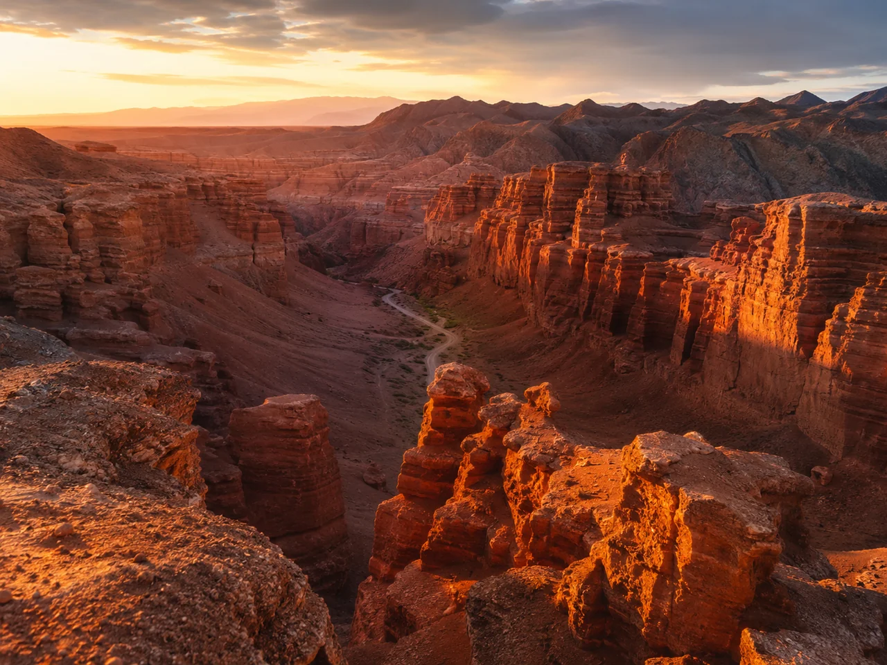
Valley of Castles: the main attraction
The Valley of Castles is the most recognizable part of Charyn Canyon, for which 90% of tourists come here. Let's figure out what explains its shape and how to photograph it.
Why the Valley of Castles is so named and how it was formed
The Valley of Castles got its name from the bizarre shapes of red sandstone, which resemble towers, fortresses, and castles: the height of the walls reaches 200 m, and the age of the rocks is about 12 million years. The red color comes from iron oxide, which accumulated in the sedimentary layers of the ancient sea that covered this area during the Neogene era. Wind and water erosion worked unevenly: soft clay layers weathered faster, dense sandstone blocks remained — so nature "sculpted" towers, arches, and niches without human intervention. If you look closely at the walls, you'll notice horizontal stripes — each layer corresponds to one climatic cycle of drought and rain, and by their thickness, geologists reconstruct the weather millions of years ago.
Best Angles and Time for Photos
The best time for photos in the Valley of Castles is in the morning before 10:00 AM and in the evening after 5:00 PM, when the sun illuminates the walls from below, turning the red sandstone fiery orange, while at noon the light is flat and texture details are lost. The most striking angle opens from the observation deck at the entrance, but if you descend 50–100 meters down the main trail, you will find yourself on a "street" between the towers — the shots become voluminous, with depth and a cinematic perspective. Bring a polarizing filter: it removes glare from sandstone wet after rain and enhances the saturation of red without Photoshop.
2026 Prices: Entrance, Transport, Tour, Accommodation
Let's summarize all expenses for a trip to Charyn Canyon in 2026: from the entrance fee to a tour with transfer.
Entrance Fee, Parking, and Infrastructure
The entrance fee to the canyon is 500 KZT per person, parking is 200 KZT, and the toilet is 100 KZT. Payment is only in cash — cards are not accepted, there are no ATMs on the highway, the nearest one is in Shelek (45 km away). A ranger is on duty at the entrance, checking tickets and giving basic route instructions. During the season (May–September), two stalls operate: at the entrance — water and snacks, at the start of the Valley of Castles — kumis and shawarma for 1,000–1,500 KZT, which is 1.5–2 times more expensive than city prices. There is no café on the premises, so bring your own lunch — sandwiches, fruits, snacks — or choose a tour with included meals to avoid paying exorbitant prices for stall food.
Cost of toor Tour and What It Includes
A tour from toor costs from 12,000 KZT per person — the price includes transfer, guide, lunch, and insurance, with no extra charges for entrance and parking. The group is usually 6–10 people, departure at 8:00 AM from Republic Square, return by 6:00–7:00 PM. The guide is a local resident from Shelek: they know safe descents into the Valley of Castles, the best angles for photos, and prevent the group from stretching out on the 7-kilometer route to the river. With a group of 6 or more, the tour is cheaper than a taxi round trip (from 50,000 KZT), and you get a guide who will lead you along the route without the risk of getting lost in the side ravines.
Summary Table of All Expenses
| Expense Item | Independent (Car) | Taxi | toor Tour |
|---|---|---|---|
| Transfer (round trip) | ~5,000 KZT (fuel) | from 50,000 KZT | Included |
| Entrance Fee | 500 KZT | 500 KZT | Included |
| Parking | 200 KZT | — | Included |
| Lunch | 1,500–2,500 KZT | 1,500–2,500 KZT | Included |
| Guide | No | No | Included |
| Insurance | No | No | Included |
| Total per person (with a group of 3) | ~7,000 KZT | ~18,000 KZT | 12,000 KZT |
If you are traveling alone or as a pair, the tour is the most cost-effective option: you pay for a ready-made program, not for fuel and taxi separately.
Practical Tips: What to Bring
We have compiled a checklist of items that will definitely come in handy on the trip: from water to a first aid kit — so that nothing distracts from the experience.
Essential Kit: Water, Footwear, Sun Protection
- Water (1.5 L per person): there are no sources of drinking water on the route, and the sun and dry air cause thirst faster than in the city.
- Closed, comfortable footwear: sneakers with a tread or trekking boots will do — the trail is rocky, the descent to the river has a 100-meter drop, flip-flops and ballet flats are excluded.
- Headgear and sunscreen (SPF 30+): from 10:00 AM to 4:00 PM, the sun in the canyon is aggressive — exposed areas burn within an hour even in cloudy weather.
- Windbreaker or light jacket: at the bottom of the canyon, the temperature is 5–8 °C lower than at the top, and the wind sharply intensifies at sunset. The most common mistake is going in uncomfortable shoes: without a proper sole, you will quickly get tired and risk twisting your ankle on the scree, and without a windbreaker, you will freeze by evening.
Additional: First Aid Kit, Food, Power Bank
Bring a light snack — sandwiches, nuts, fruits: there are no cafés in the canyon area, only stalls with water and snacks in season (prices are 1.5–2 times higher than in Almaty). A power bank is mandatory — at the bottom of the canyon, there is no coverage from any operator, the navigator does not work, and without a map on your phone, you risk losing your bearings at trail forks. A first aid kit will come in handy: band-aids (in case of chafing from unworn shoes), pain relievers, antihistamines — there are plants in the steppe that cause local skin irritation. In organized tours, the guide has a first aid kit, but your own basic set is more reliable, especially if you are traveling independently and the nearest help point is about an hour's drive to the town of Chundzha.
Safety and Route Difficulty
Let's break down how safe Charyn Canyon is, where there is cell reception, which routes are suitable for beginners, and what to do in an emergency.
Communication and Navigation: Where It Works, Where It Doesn't
At the bottom of the canyon, there is no cell service — neither Beeline, nor Activ, nor Tele2 can reach here due to the rock walls 150–200 meters high. When climbing to the plateau, the signal gradually appears: Beeline and Activ catch more stably than Kcell and Tele2, but they work at full strength only at the park entrance and the observation deck. The navigator on your phone is also useless without internet — Google Maps and Yandex.Maps do not load the route in real time. Download maps of the area in advance in the Maps.me or 2GIS app — they work offline without a SIM card, showing trails and elevations. On the main route from the entrance to the Charyn River, there is one trail, it is hard to get lost, but for side branches — for example, to the Kurtogay tract — an offline map is already mandatory.
Route Difficulty: Which One Suits Whom
There are three main routes here: the Valley of Castles (easy, 2 km along flat dirt road, suitable for everyone from children to pensioners), the trail to the Charyn River (moderate, 3 km with a 120-meter elevation change along a scree slope), and the route to the Kurtogay tract (difficult, 10+ km with climbs and sections without a trail, only for the prepared). Beginners often choose the difficult route without proper gear — this is the main mistake, causing tourists to drop out after 3–4 km and return in the heat. For the Valley of Castles, sneakers and a bottle of water are enough. For the descent to the river, you need comfortable shoes with tread and a supply of 1.5 liters of water per person — the climb back to the plateau takes 40–50 minutes. The route to Kurtogay requires trekking boots, a day's supply of food and water, as well as navigation experience — it's better not to start it without a guide.
Conclusion
We've gathered the main takeaways to ensure your trip to Charyn Canyon goes without surprises: from choosing the season to gear and travel format.
Main takeaways
- Best time to visit: April–May and September–October — comfortable temperatures and minimal crowds. In June–August it's hot (+35°C), in November–March it's cold and slippery.
- Road and transport: 3–3.5 hours by car from Almaty, the last 10 km are dirt road. For a self-guided trip, you need a car with high ground clearance or all-wheel drive.
- Gear and supplies: comfortable shoes, 1.5–2 liters of water per person, a hat, and sunscreen are mandatory. There are no cafes in the area — bring snacks with you.
- Communication and navigation: there is no signal at the bottom of the canyon, download offline maps in advance. The main route (Valley of Castles) is simple, it's hard to get lost.
- Choosing your travel format: a tour is suitable for those who value comfort and don't want to handle logistics; a self-guided trip is for experienced travelers with a prepared vehicle.