Blog
Big Almaty Lake (BAO): Complete Guide for a Trip from Almaty — How to Get There, What to See, Prices 2025
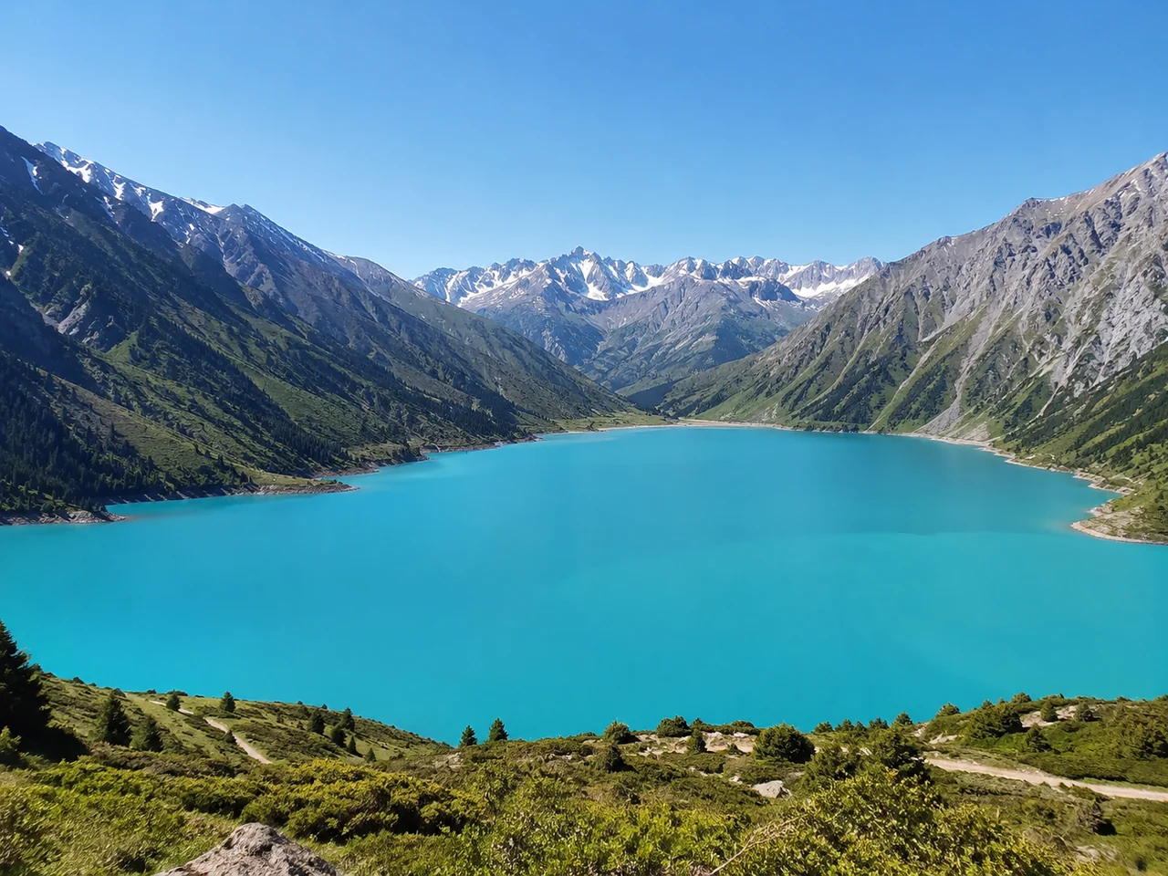
Big Almaty Lake (BAO) is a high-altitude reservoir 45 km from Almaty at an altitude of 2511 m. Turquoise water, a dam with a spillway, and trekking to the pass attract tourists from May to October. Entry requires a permit for the border zone (issued online within 5 days). Entrance fee is 460 tenge for citizens of Kazakhstan, 920 for foreigners.
What is Big Almaty Lake and what makes it unique
Big Almaty Lake (BAO) is the main natural attraction in the vicinity of Almaty: a glacial reservoir at an altitude of 2511 meters with turquoise water that changes shade throughout the season.
Why the lake is called the pearl of the Zailiysky Alatau
This reservoir is a high-altitude glacial feature in the Ile-Alatau National Park, located at an altitude of 2511 meters above sea level. The lake is dammed by the moraine of the Tuyuksu glacier: meltwater carries a suspension of glacial flour—tiny particles of rock that scatter sunlight and give the water its characteristic turquoise hue. In spring, during active melting, the lake's color is emerald with a greenish tint, and by August, when the inflow of glacial water decreases, it becomes a deep blue. In clear, windless weather, the peaks of the Zailiysky Alatau are reflected in the mirror-like surface—creating one of the most photogenic landscapes within an hour's drive from the city. The turquoise color of the water is the result of a suspension of glacial flour, which changes shade from emerald in spring to deep blue by August.
Dimensions and characteristics: length, width, depth
The lake stretches 1.6 km in length with a width of 1 km, and the maximum depth reaches 40 meters—it is the largest high-altitude lake in the vicinity of Almaty. The reservoir is fed by the Tuyuksu glacier via the Bolshaya Almatinka River, which then flows into the gorge and supplies the city with drinking water. The water surface area is about 1.1 km², and the total water volume exceeds 15 million m³. Despite its impressive depth, swimming and fishing are prohibited at BAO: the lake is a strategic source of drinking water for the city.
Why you should come here: main reasons
- Turquoise water and mountain peaks: BAO is the only place near the city where you can see a glacial lake, a dam with a spillway, and the peaks of the Zailiysky Alatau in one day without multi-day trekking.
- Dam and spillway: an engineering structure from the 1930s regulates water flow and creates an impressive cascade—a popular photo spot, especially in May-June during full discharge.
- Trekking routes: trails to the pass and the Tuyuksu glacier start from the lake—for prepared tourists, this is an opportunity to climb above 3000 meters in one day.
- Accessibility by car: unlike many mountain lakes in Kazakhstan, the road to BAO is paved and passable for a regular car—the trip is comfortable even for families with children.
Geography and climate: altitude, dimensions, weather by month
Understanding the geography and climate of BAO is key to a comfortable trip. Let's break down the altitude features, weather conditions, and what they mean for a tourist.
Altitude 2511 m: how it affects well-being and what to do
At an altitude of 2511 meters, the oxygen content in the air is 25% lower than in Almaty, so even healthy people may experience symptoms of altitude sickness: dizziness, shortness of breath, mild nausea. The lake is located in a narrow gorge between the ridges of the Zailiysky Alatau, so the climb along the serpentine road from 800 to 2500 m takes only 40–50 minutes—the sharp change in altitude does not allow the body to adapt. In our experience, about 30% of tourists report discomfort in the first minutes at the lake, especially those who arrived by car without stops at viewpoints; those who walk from the Mynzhylky dam experience symptoms less often due to the gradual gain in altitude. To reduce the risk, spend at least one day in the southern capital for acclimatization—flying in and immediately heading to BAO is the most common cause of poor health among tourists.
Weather by month: temperature, precipitation, road condition
| Month | Daytime t °C | Nighttime t °C | Precipitation | Road | Tourists |
|---|---|---|---|---|---|
| May | +10…+15 | 0…+5 | Frequent rain, wet snow | Open, wet | Few |
| June | +15…+20 | +5…+10 | Moderate downpours | Dry, passable | Moderate |
| July | +18…+22 | +8…+12 | Rare thunderstorms | Excellent | Many |
| August | +18…+20 | +5…+8 | Minimum | Ideal | Peak (weekends—queues) |
| September | +10…+15 | 0…+5 | Rare rain, frosts | Dry | Few |
| October | +5…+10 | −5…0 | Snowfalls in the second half | Open until snow | Very few |
May and September are the most photogenic months: snowy peaks contrast with turquoise water, and there are far fewer tourists than in peak August.
Why the road is closed in winter and how to get there in cold weather
From November to April, the road to BAO is closed due to snow drifts and ice—you can only reach the lake on skis, snowmobile, or on foot as part of a prepared group. The snow depth in the gorge reaches 1.5–2 meters, and avalanche danger is declared on average 3–4 times per winter, so independent outings without avalanche equipment and a radio are a direct risk. Local guides lay a route from the dam through the Kumbel pass, where the trail takes 5–7 hours one way with good physical fitness. If you are planning a winter trip, an alternative is trekking to the pass from the gorge side, but such a route requires equipment and an experienced guide.
When to go: seasons, pros and cons of each time of year
The choice of when to travel to BAO determines everything: from the color of the water to the number of people at viewpoints. Let's break down each season from a tourist's perspective.
May – June: Start of the season, greenery and meltwater
In May-June, the lake fills with meltwater — the colour is a soft turquoise with a milky tint, and the slopes are covered with bright greenery and blooming edelweiss. The road to BAO opens after avalanches have cleared (usually by mid-May), but on the upper section there may be remnants of snow on the shoulders — be prepared for a wet road. On weekdays, there are 20–30 people at the lake, not hundreds as in August — this is the best time for photos without crowds: you can calmly capture the dam and spillway without people in the frame.
July – August: Peak season, warmth and queues
July-August is the warmest and busiest period: daytime temperatures up to +20 °C, the water is a deep blue, water temperature +8…+12 °C — even the hardy won't risk swimming. At viewpoints and near the dam on weekends after 11 am, queues form for 15–20 minutes, and the parking lot fills up by 10:00 am. To avoid the tourist rush, arrive at opening time (8:00–9:00 am) or after 4:00 pm — at this time, the spillway is especially spectacular in the sunset light, and there are 3–4 times fewer people.
September – October: Indian summer, golden autumn and tranquillity
September at BAO is the perfect balance: daytime +10…+15 °C, clear turquoise water, golden birch trees on the slopes, and 5 times fewer tourists than in August. At the beginning of the month, most food and souvenir kiosks near the lower parking lot are still open, and the road remains dry and safe for a regular sedan. In October, the weather is capricious — the first snow on the pass is possible, so be sure to bring waterproof shoes and a warm jacket, even if it's +25 °C in Almaty.
Season comparison: what to choose based on your needs
| Parameter | May – June | July – August | September – October |
|---|---|---|---|
| Air temperature | +10…+18 °C | +15…+22 °C | +5…+15 °C |
| Water colour | Soft turquoise with a milky tint | Deep blue | Clear turquoise |
| Number of tourists | 20–30 people on weekdays | 200+ on weekends | 40–50 on weekdays |
| What to do | Photos of the dam, trekking on lower trails | Trekking to the pass, picnic by the water | Photos of golden autumn, trekking to the pass |
| Risks | Snow on shoulders, possible avalanche | Queues, full parking lot | Early snow in October, end of season |
If your goal is trekking to the pass, plan for July-August when the trails are dry and there's no risk of snow on the route. For photos without people, choose May or September — on weekdays, you'll be almost alone at the viewpoints.
How to get to BAO: by car, taxi, tour, public transport
The road to BAO is 45 km on asphalt, but there are nuances: a border zone, road conditions, and no public transport. Let's break down all the options.
By car: route, time, road condition
The road from central Almaty to BAO takes 1–1.5 hours — 45 km on an asphalt road through the gorge, the last 7 km are a serpentine with sharp turns, but passable in any car. The route goes along Al-Farabi Avenue to Medeu, then through the Kim-Asar gorge — signs for the lake appear 10 km before the checkpoint. The asphalt is in good condition all the way to the lake, but on the serpentine there are sections with gravel chips after winter repairs — reduce speed to 30 km/h on turns without guardrails. In season (July–August), there's enough parking near the dam, but on weekends after 11 am, entry may be difficult due to queues at the checkpoint. The navigator leads through the border zone checkpoint — don't ignore the signs: without a permit, you'll be turned away at the entrance, and the fine for violating the border regime is up to 50 MCI.
Taxi from the city: prices, where to order, what to consider
A taxi from Almaty to BAO costs 7000–10,000 tenge one way — the price depends on the car class and time of day, but getting a return ride is harder due to poor mobile reception at the lake. In apps (Yandex Go, inDrive), the fare is fixed to the lake, but drivers often ask for an extra 2000–3000 tenge for the empty return trip — confirm the total before getting in. Arranging for the driver to wait on-site is easier via inDrive: you can add a "wait for 2 hours" option when ordering, while in Yandex, it's only possible through chat after accepting the order. Negotiate with the driver for waiting time (2–3 hours will cost an additional 3000–5000 tenge) — otherwise, you risk being left without return transport, especially in the evening.
Public transport: is there a bus to BAO
There is no direct public transport to BAO — buses only go to the village of Kamenskoe Plato (10 km from the lake), and the rest of the way you'll have to walk uphill for about 2 hours. Route No. 28 from the circus in Almaty reaches the final stop "Kamenskoe Plato" in 40 minutes (200 tenge), from there — on foot along a dirt road through the gorge with an elevation gain of 400 metres. An alternative is to take a taxi to the checkpoint (about 3000 tenge from the city), then walk 5 km to the lake, but that's still an hour of walking on a serpentine without a sidewalk. The bus + walking option is only suitable for prepared tourists: the altitude of 2511 m and steep climb make this route harder than it looks on the map.
Tour with transfer from toor: what's included and how much it costs
toor organises day trips to BAO from 15,000 tenge per person — the price includes transfer from Almaty, guide services, permit processing, entrance tickets, and insurance. Departure at 9:00 am from Republic Square in a comfortable Hyundai Staria minivan for up to 7 people — the guide gives a roadside lecture on the gorge's geology and the history of the dam's construction. The route includes stops at three photo spots: at the spillway, on the dam, and at the observation deck near the cafe, which offers a view of the entire lake's curve. Compared to a taxi (7000–10,000 tenge just for the road), a guided tour solves all organisational issues: you don't need to apply for a border zone permit yourself, search for the best angles, or worry about return transport.
Border zone and permit: how to apply, deadlines, cost
BAO is located in a border zone — without a permit, you will not be allowed through the checkpoint. Here’s how to apply for the document online and how much it costs.
Who needs a permit and why BAO is a border zone
A permit for the border zone is mandatory for all visitors to BAO — the lake is located 28 km from the border with Kyrgyzstan, and the entire territory of the Ile-Alatau Park has the status of a border zone. This requirement applies to citizens of Kazakhstan, foreigners, and children without exception — control is carried out at the stationary checkpoint No. 4 "Ayusay", where KNB Border Service officers verify the document data against the electronic database in 1–2 minutes. The check is quick, but without a permit, cars are turned back, and pedestrians are sent away. The exception is organized tours: the guide applies for a permit for the group centrally through e-gov.kz, and the tourist only needs to provide their passport or ID card details when booking.
How to apply for a permit online: step-by-step instructions
- Register on e-gov.kz: log in via digital signature or a one-time password using your IIN — without registration, submitting an application is not possible.
- Find the service "Issuance of a permit to the border zone": in the portal search, enter "border zone permit" and select the KNB Border Service service.
- Fill out the electronic application: provide your full name, IIN, date of birth, registration address, and contact phone number — all fields are mandatory.
- Attach a scan of your ID: upload photos of both sides of the document in JPG or PDF format, the file size must not exceed 5 MB.
- Specify the date and purpose of the visit: in the "route" field, write "Big Almaty Lake", and for the date, enter the planned day of the trip — the permit is valid only for the specified date.
- Submit the application and wait for a notification: the status can be tracked in your personal account, and the completed permit arrives by email in PDF format — printing is not necessary, just showing it on your phone screen is enough.
- Submit your application at least a week before the trip: during peak season (July-August), processing may take up to 7–10 days due to the influx of applications.
Entry fee: 460 tenge for citizens of Kazakhstan, 920 for foreigners
Entry to BAO costs 460 tenge for citizens of Kazakhstan and 920 tenge for foreigners — payment at the checkpoint by card or cash, though terminals are unstable. For citizens of Kazakhstan, a ticket is purchased upon presenting an ID card; for foreigners, a foreign passport with valid registration. Children under 14 enter for free, but a permit is issued for each child separately — the data is entered into the application via e-gov.kz. In organized tours, entry tickets are included in the cost — the guide pays for everything in advance and does not delay the group in the ticket queue.
What happens if you arrive without a permit
Without a permit, you will be turned back at the checkpoint — entering the border zone without documents is classified as an administrative violation with a fine of up to 50 MCI (about 184,600 tenge). Border Service officers draw up a report on the spot, and a copy is sent to the district police department at the violator's place of residence. A repeated violation within a year risks an increased fine of up to 100 MCI or administrative arrest for up to 15 days — this practice is known from cases involving tourists who tried to drive along bypass forest roads, where a camera system records car numbers at the entrance to the gorge. Attempts to bypass the checkpoint are dangerous due to serpentine road exits and are monitored — a fine and being turned back are guaranteed.
What to see: the lake, dam, spillway, trekking to the pass
BAO is not just the lake itself. The dam, spillway, trekking to the pass, and observation platforms — here’s what you absolutely must see in one day.
Dam and spillway: the main engineering attraction
The BAO dam is a 30-meter concrete wall built in the 1970s to regulate the flow of the Bolshaya Almatinka River, and the spillway is the most impressive feature: during peak glacier melt, water crashes down from a height, creating a rainbow in sunny weather. The dam structure is earthen with a concrete core — its length along the crest is about 200 meters, and its thickness at the base reaches 15 meters. The spillway is an open chute 3-4 meters wide, through which water is discharged into the gorge; the flow rate at the height of summer reaches 10-15 cubic meters per second. On the lower side of the dam, there is an observation platform — from there, you can see the water breaking against the rocks 50 meters below. The spillway does not always operate — maximum water discharge occurs in July-August when the melting of the Tuyuksu glacier is most active; in May and September, the flow is weaker but still impressive.
Trekking to the pass: route, difficulty, time
Trekking around BAO to the pass takes 2–3 hours one way — a moderate-difficulty route with an elevation gain of about 300 meters, offering a bird's-eye panorama of the lake. The trail starts from the eastern shore, runs along the slope of the Ile-Alatau ridge, then climbs in switchbacks to the saddle — the final section is the steepest, with a gradient of 25-30 degrees. Along the route, there are three springs, but the water requires boiling — it’s better to bring a supply of 1.5-2 liters per person. The altitude of 2511 meters makes itself felt even during a small climb: take breaks every 20–30 minutes to even out your breathing and reduce strain on the heart.
Observation platform near the cafe: the best view of the lake
The observation deck near the café on the eastern shore is the most popular spot for panoramic photos: from here, the entire reservoir is visible, and the dam, spillway, and mountain peaks of the Zailiysky Alatau range are captured in the frame. The deck is equipped with a wooden platform and railings, making it safe to stand even in windy weather. On a clear day, peaks at 3500-4000 meters are visible: Tuyuksu, Kumbel, and Ordzhonikidze. Arrive at the deck before 10:00 AM — at this time, the sun illuminates the lake from the east, the water takes on a rich turquoise hue, and the snowy peaks are clearly visible in the background.
Shore opposite the dam: tranquility and wildlife
The shore opposite the dam is a place for those who want to escape the crowds: tourists rarely reach here, and the view of the dam and spillway from the opposite side is no less impressive. You can reach it on foot via the trail along the western shore — the walk takes 15-20 minutes from the observation deck. Here you can encounter marmots and mountain goats — the animals are accustomed to people and allow close approach, but do not feed them: this disrupts their natural diet and harms their health.
Photo spots: where to get the best shots of turquoise water
The turquoise water of BAO is the main subject for photos. We'll tell you where to stand, what time to shoot, and how to get shots without crowds of tourists.
The dam: a classic angle from above
From the dam, the entire bowl of the lake opens up — this is the most recognizable angle of BAO, featured in all tourist brochures of Kazakhstan. Stand at the parapet directly above the concrete base of the dam: from this point, the turquoise water occupies the lower third of the frame, and the jagged rocks of the Kyrgyz Range stretch into the sky. A cloudless morning provides maximum contrast between the icy-blue water and dark granite slopes, while in cloudy weather, the lake becomes leaden-gray and loses its volume. The best time for shooting from the dam is early morning (8:00–9:00 AM): the sun illuminates the water from the side, the turquoise color is most saturated, and shadows from the mountains create depth in the photo.
Observation deck near the café: panorama with the dam and spillway
From the observation deck near the café, three objects are captured in the frame: the turquoise water, the concrete arch of the dam, and the roaring spillway — an ideal compositional center for a panoramic shot. Climb onto the concrete barrier to the right of the café entrance — from there, you can see the water cascading over the edge of the dam and noisily falling into the gorge. On a sunny afternoon, the spillway creates a rainbow in the spray, which lasts 10-15 minutes at a certain angle of light, but from 12:00 PM to 2:00 PM, the water in the lake fades to a pale blue. To avoid glare on the water, use a polarizing filter — it removes the reflection of the sky and makes the turquoise color as deep and saturated as possible.
Shore opposite the dam: shots without crowds and with wildlife
The shore opposite the dam offers a rare angle where the dam and spillway are fully visible, and tourists and infrastructure are not in the frame — only water, mountains, and the concrete arch. Descend to the water along the trail that skirts the lake on the left side of the dam — after 200 meters, you'll reach a pebble beach where argali occasionally graze. From this spot, the dam looks toy-like against the vast bowl, and in calm weather, the water becomes mirror-like, reflecting the sky and rocks — shoot strictly horizontally so the horizon line divides the frame in half. For portrait photography, select the "portrait" mode on your smartphone with focus on the person and a blurred background — this way, the turquoise water becomes a soft color patch without overloading the composition.
Conclusion
A trip to BAO is not a spontaneous picnic but a well-planned adventure involving high-altitude acclimatization and bureaucracy. Here are the main takeaways from our guide.
Key takeaways
- Plan your trip for July–September — during these months, the water is most turquoise, the road is open, and the weather is stable for walks.
- Arrange your permit in advance — without it, access to the lake is closed, and the process takes up to 5 business days via e-Gov.
- Consider the altitude of 2510 meters — even healthy people may experience mild altitude sickness, so bring water and avoid active trekking in the first hour.
- Choose a weekday for your trip — on weekends and holidays, the observation deck and dam are crowded with tourists, and the parking lot is full.
- Bring warm clothing even in summer — at altitude, the temperature is 10–15 °C lower than in the city, and the wind near the water intensifies the feeling of cold.